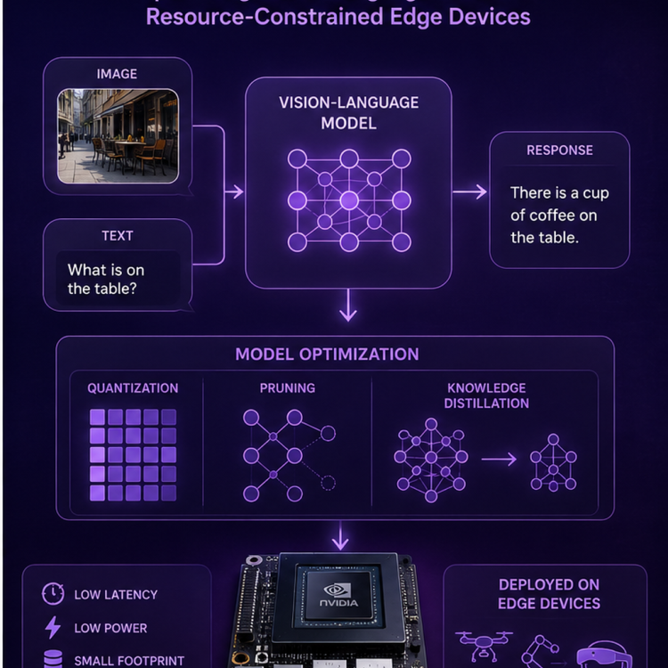
In EdgeVLMOpt (EVO): Optimizing Vision-Language Models for Resource-Constrained Edge Devices, we aim to develop efficient and scalable techniques to enable the deployment of advanced vision-language models (VLMs) on edge hardware. While VLMs have demonstrated strong capabilities in multimodal reasoning and understanding, their high computational and memory demands pose significant challenges for real-time, on-device applications.
Research projects in Information Technology
Displaying 1 - 10 of 12 projects.

EdgeFusionAI (EFAI): Real-Time Multi-Sensor Multi-Modal Intelligence on Edge Devices
In EdgeFusionAI (EFAI): Real-Time Multi-Sensor Multi-Modal Intelligence on Edge Devices, we aim to design and develop efficient techniques for fusing heterogeneous sensory data, including vision, LiDAR, radar, and other modalities, to enable robust and real-time decision-making on resource-constrained edge platforms. This project focuses on building intelligent systems capable of integrating diverse data sources while addressing the challenges of limited computation, memory, and energy availability at the edge.
Supervisor: Dr Mohammad Goudarzi

Development of a GIS-Based Model for Active Citizenry
Development of a GIS-Based Model for Active Citizenry
Supervisor: Prof Aamir Cheema
Street-Level Environment Recognition On Moving Resource-Constrained Devices
Street-Level Environment Recognition On Moving Resource-Constrained Devices
Supervisor: Prof Aamir Cheema
Autonomous Vehicles for Urban Transit Optimisation
Public transportation is vital for sustainable urban mobility, yet challenges like inefficient first- and last-mile connectivity, and over-reliance on private cars hinder its effectiveness. Autonomous vehicles (AVs) offer transformative potential by enabling diverse, on-demand mobility solutions tailored to specific trip needs, enhancing connectivity, and reducing emissions. However, current research often overlooks the complexities of mixed-vehicle environments, and the development of optimal deployment, routing, and charging strategies.
Supervisor: Dr Mohammed Eunus Ali
Explainable AI (XAI) in Medical Imaging
Are you interested in applying your AI/DL knowledge to the medical domain?
This project focuses on the use of AI in Medical Imaging (e.g. CT, MRI, X-Ray, Ultrasound, etc). The work includes segmentation and classification; for example, segmenting tumour from the medical images, and then classify the grade of the tumour. We will use various Deep Learning techniques, such as CNN, and will experiment with a variety of Deep Learning frameworks, such as U-Net, ResNet, etc.
Supervisor: Assoc Prof David Taniar
Navigation and Point of Search in Road Networks
Modern map-based systems and location-based services rely heavily on the ability to efficiently provide navigation services and the capability to search points of interests (POIs) based on their location or textual information. The aim of this project is to build a next-generation navigation system by addressing limitations in the current systems – such as allowing more meaningful distance measures, modeling uncertainty in data sources and queries, and exploiting rich information from several data sources.
Supervisor: Prof Aamir Cheema
Using Big Spatiotemporal Data for Road Safety
On their own, traffic accidents cause 1.3 million fatalities every year – and improper situational awareness is often a major cause. This project aims to exploit big spatio-temporal data to design intelligent techniques for scheduling and offloading tasks to the cloud and peer vehicles. This will ultimately meet the Quality of Service (QoS) requirements of time-critical road safety applications and increase situational awareness by automatically identifying unsafe road conditions and risky driving behaviors – and sending alerts in real time to affected vehicles.
Supervisor: Prof Aamir Cheema
Eco-friendly Road Transportation
This project aims to harness big data from ubiquitous smartphone sensors to reduce the impact of road transport on the environment. Specifically, we’ll design novel data modelling and indexing techniques to exploit the data and create a next-generation, eco-friendly navigation system which will significantly reduce greenhouse gas emissions and result in fuel saving. The initiative also aims to study the citywide impact of adapting to eco-friendly navigation on traffic, environment and road safety – therefore supporting urban planning and decision-making.
Supervisor: Prof Aamir Cheema
Map Data Analysis
This project heavily focuses on maps (e.g. GoogleMaps or Open Street Map). We will explore various properties of road networks, including the granularity of road networks, routes and trajectories on road networks, and query processing on road networks.
A number of inter-disciplinary collaboration exists, including transportation to hospitals, urban sprawl analysis, and geospatial in sustainability (e.g. analysing placement of rubbish bins on streets).
Supervisor: Assoc Prof David Taniar